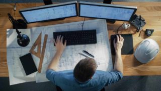
With LIDAR, you can skip truck rolls and sell to your customers with confidence. Accurate system design and bankable shade reports can be generated quickly and remotely. To put that in context, accurate remote site assessment could save you the equivalent of half the cost of an average string inverter!
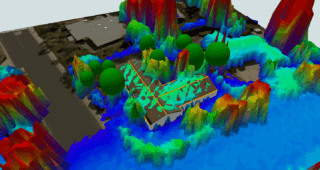
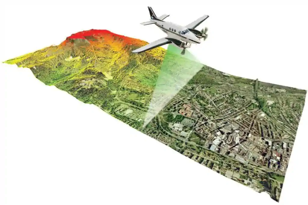
Aurora uses 3-dimensional LIDAR data to calculate building heights, roof slopes, and tree heights. LIDAR data is also used to calculate how much irradiance (sunlight) and shading is cast on a rooftop, so sites can be quickly screened for their solar potential.
This post covers some of the top questions that were asked during our recent webinar, Optimize Your Solar Design Process with LIDAR in Aurora. You can watch the replay of the webinar here.
Aurora’s LIDAR availability
How do we gain access to this feature in our account?
LIDAR is available to Premium and Custom accounts with Aurora. (Contact customer support to learn how you can activate it on your account.)
Where is Aurora’s LIDAR available?
The best coverage is in the United States and North America, in general. As you can see above, there is some coverage in Canada and Mexico. Other international coverage is a bit spottier. You can check our coverage all over the world here.
Do Nearmap images use the same LIDAR data?
No, Nearmap and LIDAR sources are totally different data sets. Nearmap gives us the latest and greatest 2D, top-down satellite imagery, while LIDAR gives us a 3D topographical representation of a location. This makes them great to use in tandem, to get more information in order to make the best design possible. To learn more, see our help articles:
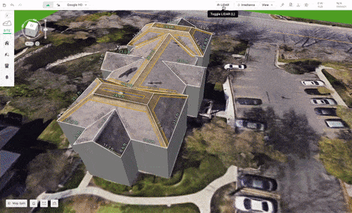
How to use LIDAR in Aurora
Is there a simple, step-by-step template that shows which tools to use and when?
We offer training sessions to help, plus some help center articles. Here is another helpful tutorial!
An easy sequence to remember would be:
- Obtain the best imagery possible
- Enable LIDAR data if available
- Align the imagery in LIDAR
- Start drawing right away. Outline the pitched or flat roof.
- Once have basic structure, toggle LIDAR on and off to keep adjusting
Also, be sure to use Google Street View in Aurora where available. This will help you measure and adjust for a better design.
Where’s the LIDAR shading enable/disable button to toggle it on and off?
There are two options:
- You can enable or disable LIDAR for all of your projects by going to your settings page.
- Your second option is to use LIDAR on a specific design. To do this, go to your design, click on the gear box, or settings symbol, and click “simulations.” You can use this to toggle LIDAR on and off.
Is there any way to get drawn in objects to be blocks or polylines?
(For example, sometimes when a design needs to be modified in Auto CAD, it can be somewhat cumbersome to move multiple lines instead of a single block.)
Yes. Our tool is based in a CAD window, so you can draw obstructions. (Please see the full webinar for an example using a basic chimney.) You can move the rectangle height up and down without having to move individual lines. However, when the DXF file is exported to be used outside of Aurora, this is no longer the case and the output is a 2D orthographic projection of the design as polylines.
What if the LIDAR data looks to be off or is behaving oddly?
If you are experiencing any issues, please contact Aurora support (support@aurorasolar.com) to help troubleshoot.
Aurora’s LIDAR data accuracy & recent update
Does the LIDAR info specify the date the data was taken?
(For example, so we know if a tree was removed before or after the LIDAR data.)
Yes. You can check LIDAR age here.
What if the date LIDAR data was taken for a certain area seems old?
(For example, if it’s listed as 2010.)
The average LIDAR age decreased overall in our recent 2022 LIDAR update. We rely on agencies like USGS and NOAA, so if they haven’t surveyed an area for a long time, then we not have any updated information. We do QA data and would trust that the 2010 data will still be helpful to use for your designs.
If the LIDAR is refreshed, how accurate will tree height be?
LIDAR accuracy depends on a couple different factors such as the LIDAR age and point density. Our 2022 LIDAR refresh improved the average age and point density of our LIDAR data.
LIDAR axis positions & slopes
When you change the LIDAR axis positions, does it affect the production simulation?
When changing the X, Y, or Z axis, everything moves at the same time in the chosen axis. Individual obstructions do not move separately. Therefore, this shouldn’t change the production and shading values on the roof surface.
If we can offset the X, Y, Z coordinates in LIDAR how do we decide which one is correct? The default or offset?
The main reason to use these offsets is if the default LIDAR data doesn’t match the imagery that you chose. That means, when you toggle the LIDAR data on, certain ridges or features might be a little off from the image you chose. Lining up a high-quality image with LIDAR helps you make a better design. If you were to adjust the X offset, everything in the data set moves by the same amount in that axis. You wouldn’t be able to just move a tree or the roof with the X/Y/Z coordinate adjustment, for example.
Does LIDAR have information on slope of ground?
(For example, for designing on steep hills.)
The remote sensing aircraft surveying the ground below is taking measurements not just of houses, but of the topography around the houses. If you move the Z access up and down, you can see the topography and how the hill shows in LIDAR data. This will give you a better idea of the structure’s surroundings.
What if there’s a project where the LIDAR data may not be 100% accurate?
(For example, the roof appears flat, but is sloped IRL.)
LIDAR is a really helpful tool to use when you design on your own, no doubt. But for those projects where it doesn’t fit for any reason, we also offer an expert design service that uses all of the tools Aurora has to offer to create extremely accurate design for your team. We can design a system with the turnaround time of under 30 minutes or under 3 hours — depending on what you need. Plus, you can approve or reject a design.
If I turn off LIDAR but keep horizon shading on, what exactly will render?
(For example, do you need to draw the house on the hill if you want to include it?)
LIDAR data and horizon shading data are independent of each other. Horizon shading can still apply if that’s what you chose in your settings, even when LIDAR is not on or not available.
Trees in LIDAR
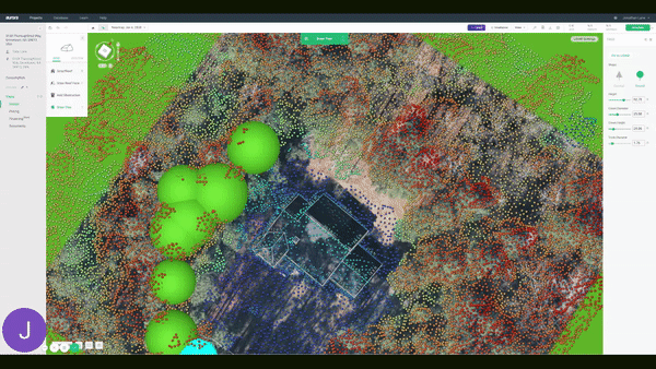
What’s the point of adding a tree if the LIDAR already captured it?
Sometimes, you might want to draw the trees out yourself if you disable LIDAR shading and want more control of surrounding obstructions and shading sources.
How much does the type of tree modeled affect shade calculations? Are bare deciduous trees accounted for when considering winter production?
The LIDAR data is from a snapshot in time, so it really depends when surveying aircraft captured that tree. But whether it’s summer or winter, there isn’t a huge percentage leaf shading difference in your design.
When LIDAR shading is on do you need to draw the trees or obstructions?
No. If you use LIDAR shading, you don’t need to draw external obstructions like trees. Shading doesn’t take into account obstructions on the roof itself like chimneys.
Do you recommend drawing the trees or using the original LIDAR?
That depends on the quality of the LIDAR data. Sometimes LIDAR data is old and the point density is not great. You can check the LIDAR quality in terms of age, point density, and source, whether it’s sourced from GOOGLE 3D or the Aurora LIDAR data set. Based on these factors, you can determine whether it is best to draw all the trees and surrounding obstructions yourself or use LIDAR shading.
Additional LIDAR resources
If you have any additional questions about LIDAR in Aurora, please reach out to our support team at support@aurorasolar.com, or schedule a quick, no-pressure demo.
Interested in learning more about Aurora’s features? Sign up for our weekly Wednesday webinar How to Sell with Aurora in 20 Minutes to see Aurora in action.