 One of the biggest factors in whether a site is suitable for solar — and how much energy it will produce — is trees. They’re beautiful, we all love them, but having a big tree shading a roof can be an impediment to generating solar energy.
It follows, then, that being able to accurately represent trees, both the size and shape, in your solar design is critical. Yet, many solutions rely solely on you to estimate the height and breadth of a tree that could impact a site’s potential by kilowatts.
Why Sizing Trees Accurately is Important
In our last entry, Using AutoDesigner to Size a System Correctly, we dove into the pitfalls of an incorrectly sized system. Long story, short: An incorrectly sized installation — whether it produces less energy or more energy than expected — can lead to unhappy customers and/or unprofitable systems.
When it comes to trees, this can mean a couple things. The most obvious is that on a heavily wooded property, the size and shape of trees can literally be the difference between a site being viable or not.
In the sales process, it’s also important to remember: Homeowners often over-estimate the impact of a tree. So, a homeowner objection might be something like, “No, we can’t go solar, because of that big palm tree there”. With Fit Trees to LIDAR, though, a good solar sales rep can say, “Actually, let’s model it quickly, the shade impact might not be as big as you think”.
How Aurora’s Fit Trees to LIDAR Helps
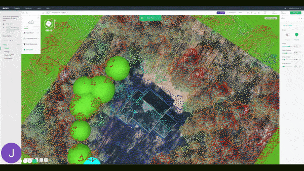
Fit Trees to LIDAR eliminates guesswork and saves you time when adding trees to your project by intelligently adjusting the height trees to match Aurora’s LIDAR data.
When you add a new tree to a project, Aurora will automatically look for LIDAR data points in that location and adjust the Tree Height and Crown Height accordingly. This helps ensure that your designs are as accurate as possible, and saves time by intelligently adjusting those tree features, rather than you having to estimate them, redraw them, and possibly visit the site again to accurately measure.
Imagine you’re designing a site with dozens of trees on the property. Instead of manually adjusting each of the trees one-by-one, all you need to do is draw the tree out initially and it will adjust to the correct height. This cuts the time it takes to design trees dramatically. Then, think about how much time that could save when designing tens or hundreds of homes
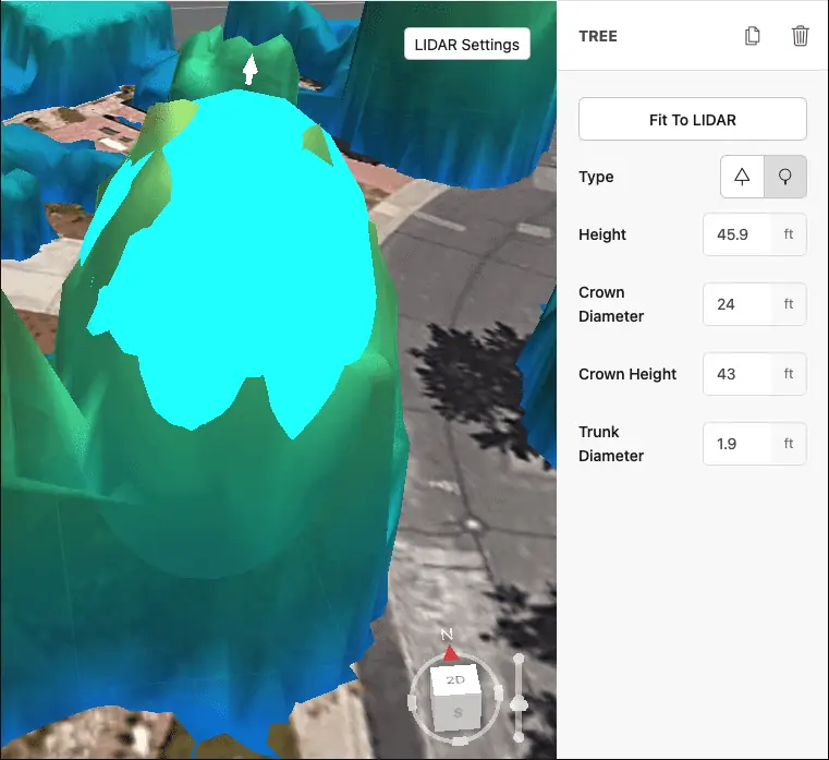
How Fitting Trees to LIDAR Works
Using this feature couldn’t be easier. When you add a new tree, Aurora will automatically look for LIDAR data points in that location and adjust the Tree Height and Crown Height. As you can see in the GIF below, it just happens.
If LIDAR hasn’t finished downloading or isn’t available for that site, you’ll still have to manually adjust the height of the trees, or click the “Fit to LIDAR” button in the Tree Inspector once it finishes downloading. You can override the Fit to LIDAR values by adjusting the tree’s height, or changing the tree’s shape (cone to sphere, sphere to cone). See Aurora’s Help page for more information.
And that’s it. No more guesswork, no more back-and-forth.
We’ll be back next week with feature #5. In the meantime, check out our dedicated 10 Things You Didn’t Know Aurora Can Do homepage to learn about the other things we’ve featured so far. Then schedule a live demo to learn more about how these features can help you produce more accurate solar designs.
Do you have suggestions for an issue or feature you’d like to see covered? We’ll have some Aurora gifts for any ideas we use. Email us here.